
What kind of a map are you trying to make?

21 users logged in
Proud partner of GDC 2025

Before posting, review our community guidelines.
Support GameDev.net with a monthly GDNet+ subscription!
best way to "sculpt" terrain c++ directx

March 01, 2022 12:07 PM
Acosix said:
What kind of a map are you trying to make?
Just learning stuff… nothing great…
March 02, 2022 05:48 AM
Acosix said:
What kind of a map are you trying to make?
what does artist inside you says? what should be done, what kind of map should be it, what is best?

4,399
March 02, 2022 07:34 AM
Enzio599 said:
what does artist inside you says? what should be done, what kind of map should be it, what is best?
We can assume in general the erosion process creates sediment, which then forms a flat sole in the valleys. That's kinda easy to model.
So the harder problem is to get the ridges of mountains, as they are not flat.
Example image of Dolomites:
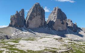
Which is a example showing both the flat sediment at the bottom, and spiky mountains peeking through at the top.
Interestingly, i see this landscape as an average case of the two extremes of mountains, which are:
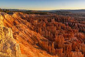
1. Sandstone kind of stuff, heavily eroded by water and wind, generating noisy columns, e.g. National Parks in Utah:
2. Solid mountain ranges forming connected peaks with long and clearly defined valleys in between, like my homely Alps:
Before trying to simulate this, i did not spend much effort on a detailed understanding of the processes involved generating such shapes.
Now i do, and i constantly observing nature, imagining what might have happened in the past to cause the current state.
You need to do this, no matter if you are artist or toolmaker. It takes time, but it helps.
The main processes are tectonics and erosion.
Tectonics causes landmass to compress in some regions. The compression generates folds. Similar to how you get folds in a sheet of cloth if you lay it on a table and push it together with both hands from two sides.
The folds give us peaks, or local maxima of hight in a hightmap. (2D tools usually give such initial state of having peaks using a noise function. A 3D simulation can actually simulate the folding process itself.)
After that, the erosion by rain preserves those peaks, but drags other material downwards, which gives us the tendrils forming connected valleys, always flowing downwards. This also generates the usual pyramid shaped mountains, with a peak a the top, widening but rarely narrowing downwards.
(2D erosion simulation gives nice tendrils pretty easily. In 3D it's much harder. Generating them manually with painting or sculpting surely is a skill which only very few artists intend to develop.)
Those processes give us a coarse idea and shape. Looking at the surface of rock in detail, it again shows us two extremes:
1. Smooth rocks, usually to be found near water flows, where the flow erosion generates a smooth / round surface.
2. Noisy, spiky, broken surface. Where the shape is mostly defined from destruction. Parts of rock break and fall down, what remains is a boundary entirely defined by damage.
At this point we eventually realize: We hopefully can model those shapes again using the same processes, just at different scales.
Erosion simulation already gives us kind of land slides which cause the braking damage.
Tectonics, which i personally achieve by expanding matter so it forms folds, can also give nice propagation of cracks if we contract/shrink the matter, instead expanding it.
This may sound a bit confusing / complicated at this point, but it's the explanation of why i say we need to do simulation at multiple frequencies to get natural results.
Meaning for example: We do the same simulation passes in all mips of a heightmap and sum them together, so our modeling of various processes applies at all scales, eventually with different settings per mip.
Now i don't have any experience with terrain sculpting, but i imagine the same idea would be useful here too. The user could eventually select on which mip level he actually paints. And you internally keep all mips individually and show their sum as the final result.

4,399
March 02, 2022 10:29 AM
Some update on my personal 3D crusade:
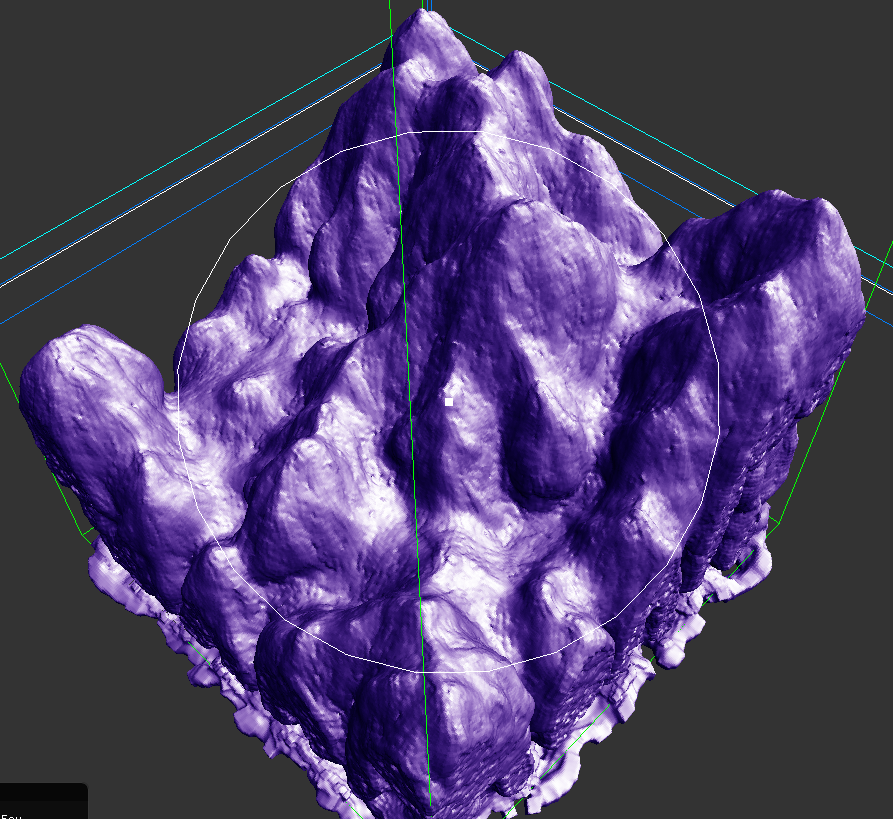
I try to get really steep mountains, even forming some overhangs so i can do some things hightmaps couldn't.
Two weeks ago i already gave up on this, but then decided to finish it anyway as it's closely done. Support for tiled simulations was missing, which i have completed yesterday.
So the basic pipeline is working, and now i need to do lots of parameter tweaking (again) to see if i can get nice results or not… 2D really is orders of magnitudes faster, so i'm still unsure ; )
This topic is closed to new replies.
Advertisement
Popular Topics


Advertisement
Recommended Tutorials


Advertisement